Hull’s River Bridges: Peter Marshall – River Hull’s Bridges 1977 – 1988
We came across photographer Peter Marshall when starting the book A River Full of Stories and discovered, via his Cafe Royal publication The River Hull 1977 – 85, an unrivalled body of work that documents the changing landscape of Hull from the early 1970s and his photographs have enabled the stories in the book to come back to life so vividly.
We recently had the pleasure of meeting Peter and his wife Linda over a pint on their most recent visit to Hull.
Peter’s exhibition at the Ferens Art Gallery in Hull in 1983 – ‘Still Occupied…’ a View of Hull 1973 – 1986 can be found here: http://hullphotos.co.uk/
You can read Peter’s thoughts about his own photographs and about current issues and photography on his website http://re-photo.co.uk/
Here Peter documents some of the river’s bridges and observations between 1977 and 1988.
All photographs and accompanying text are copyright Peter Marshall.

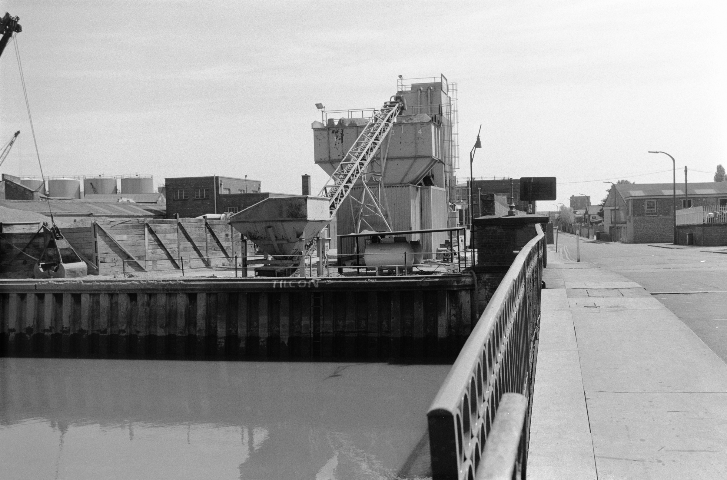
Wilmington Bridge, Hull, 1980

River Hull from North Bridge, Hull, 1985
In the distance are the raised Drypool Bridge, apparently under repair and on the left the Clarence Flour Mills. On the left the moored dredger, Burcom Sand, with a barge moored alongside. Under the bridge can be seen the Trinity House Buoy Shed and immediately to its right an old warehouse. Below this is the entrance to a dry dock and then to the right one of two sheds belonging to the Yorkshire Dry Dock Co Ltd, Shipbuilders ship repairers – as it helpfully states on the second shed at far right. Between the shed is the entrance to Queen’s Dock Basin, converted to use by the company as a dry dock at some time after Queen’s Dock was filled in during the 1930s.

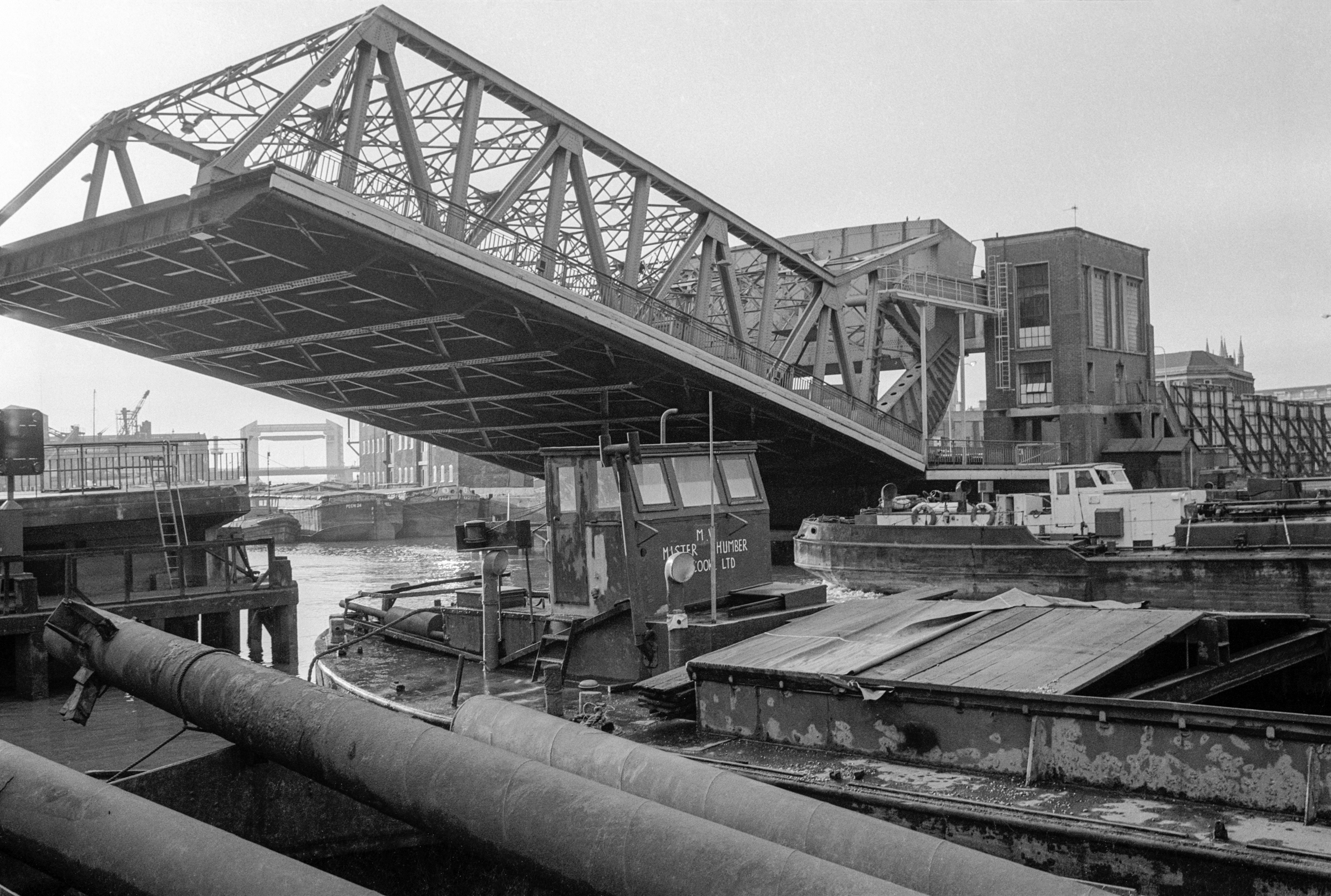
The Humber Star goes through Scott Street Bridge, Hull, 1983
Two men share a few words with a member of crew as the Humber Star goes through Scott St Bridge, the flag of John H Whittaker (Tankers) Ltd clear on its funnel. The two men on the bridge are, I think, the bridge operators, with a small panel behind them with electrical cables leading off left. The two bascules of Scott St. were raised by an electrically powered hydraulic system, which when first built was presumably linked to the nearby hydraulic power station, the first such public utility in the UK. The Grade II listed bridge has been held in raised position to road traffic for years and allowed to decay by Hull Council and was removed in 2020.
The vessel was actually going backwards upstream slowly on the tide, and I took four pictures as it approached and came through the bridge (this was the last), as well as one of the bridge opening before it arrived. The river here is too narrow for a vessel of this size to turn around.
At the wharf beyond is Bonby, empty and high in the water and waiting to be loaded with sand or gravel. Bonby is a village in North Lincolnshire a few miles south of Barton upon Humber.

River Hull, West (left) and East (right), Scott St Bridge, Hull, 1988

Drypool Bridge and River Hull, Hull, 1985
The Drypool Bridge is raised for the small Rix tanker Bledale H to reverse through underneath, though it looks as if there might have been sufficient clearance without it opening, but the water is fairly high close to high tide.
The photograph is taken from the riverside path underneath Joseph Rank’s Clarence Mill, where another small vessel, possibly an oil tanker, is moored with crew on board.
In one of the more senseless acts of recent years in Hull, the Clarence Mill, an iconic local landmark, was recently demolished, and the site has lain empty for several years. It was meant to house a new hotel for Hull 2017 Year of Culture, but not a stone on the site was turned and it seems that this was simply used as a pretext to gain permission to demolish one of Hull’s best-known and loved buildings.
On the other side of the river is a block of warehouses, demolished in the late 1980s, another sad loss to Hull’s heritage. Again the site has since remained empty, used only for car parking.
Drypool Bridge raised for traffic on the River Hull, Hull, 1982
“A lift-bridge having a moveable span provided at one end with a curved part adapted to rest and roll upon a stationary supporting surface. Other characteristics noted in the patent include: teeth or projections on the said curved part adapted to interlock with projections on the supporting surface to hold the said curved part from moving or slipping on said surface, and means for moving the span, comprising a horizontally moving part connected with the span at or near the central point of said segmental or sector-shaped part.”
This design takes up little space and by rolling backwards away from the river it leaves this entirely clear for navigation. With the weight of the bridge being balanced by a heavy counterweight at its rear, relatively little energy is needed to raise the bridge. It was a remarkably simple and elegant invention.
As a part of the celebrations in Hull’s year as City of Culture, Drypool Bridge has recently been repainted from its rather plain blue (enlivened by a little rust) to a pattern celebrating Victorian mathematician John Venn (1834-1923), born in Drypool where his father was rector. He moved away from Hull when he was seven and attended schools in north London before going to Cambridge. So far as I’m aware he had no further connection with Hull. But the bridge does look quite pretty.
I’ve not been able to find any information about MV Mister Humber moored in the foreground. The two barges in the distance are Poem24 and Kago.

Myton Bridge, Hull 1980

Tug, Scott St Bridge and High Flags Mill, River Hull, Hull, 1977
A Hull-registered tug makes its way upstream under Scott St Bridge past the Jolly Miner moored at a wharf for her load of sand or gravel to be unloaded at a Lime St wharf. In the background are the two linked buildings of the High Flags Mill, an oil mill built around 1856. The crushing of agricultural grains, some imported from the Baltic, to produce edible and non-edible oils was an important industry along the River Hull.

Wilmington Bridge, River Hull, Hull, 1983
The first railway bridge on this site was built in 1853, to carry the Victoria or East Dock Railway over the River Hull. A single line bridge with speed and axle load restrictions it became inadequate to deal with the growing traffic to the Eastern docks as well as that going to Hornsea and Withernsea, and was replaced with a twin track bridge, with Hull Corporation paying the extra needed to provide a foot and cycle way along its north side. From 1864 it was also used by trains from Hull to Hornsea on the Hull and Hornsea Railway which diverted from the Victoria Dock Branch at Wilmington Station just to the east of the bridge.
This old footbridge and cycle path is now longer in use, instead there is a wider foot and cycle path where the trains used to run. When Dr Beeching short-sightedly axed much of our railway network, passenger trains to Hornsea and Withernsea stopped in 1964 but goods traffic on the Victoria Dock line continued until 1968. The Hornsea line was a useful route and well-loved and could well have survived at least in parts as a light rail project; much is now a walking and cycling route.
The bridge opened by rotating around a central axis under the operating cabin, powered by two powerful electric motors, with the electricity being supplied through high-level electrical cables. The bridge had a three-man crew – a mechanic and two steersmen with each motor having its own controls, and the system also required three manned signal boxes, one also serving the nearby Wilmington station. The 160 foot long bridge which weighs around 500 tons could be opened and closed in around 2 minutes. When open there was 53ft 6in of clear water to the west of the bridge and it had been designed so that a further river channel could if ever needed be dug on the east side allowing another 40ft of passage.
The Grade II listed bridge was restored in 1991 and the opening mechanism is said to be in full working order. It is one of 12 Hull bridges due to be opened (plus one long permanently open) in an event on the Autumn equinox creating “a symbolic wall denying the freedom of movement across the city” between East and West Hull as part of Hull 2017’s Freedom Season. The River Hull has always been a symbolic and physical divide between the two.
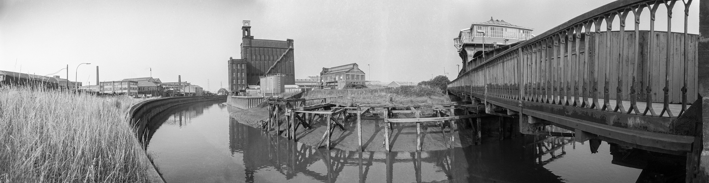
River Hull, Wilmington Swing Bridge, Hull, 1983
I made a series a series of five images which together covering a 360 degree view from a position close to the end of the bridge. These were of course taken on film; in Hull, 1983 digital images hardly existed and were generally crude and pixelated – or even made up of ANSI characters, and I don’t think digital image stitching software existed as there was nothing for it to stitch. I intended not to produce a single panoramic image but a series of images that would be mounted in sequence with a small gap between them.
Making actual photographs join together before the days of digital stitching was a very tricky business, and would have needed rather more pictures, preferably taken with a longer lens, careful cutting of prints with a scalpel, shaving the edges and glueing them together, retouching with a brush and diluted black dyes and then re-photographing the whole. It was only really possible with very carefully taken images using standard or longer lenses.
These pictures were taken with a wide angle – probably a 21mm or 28mm lens – and the distortion inherent in rectilinear wide-angle images would have made accurate joining impossible.
It was easier to use a panoramic camera, but these were generally expensive – with some costing the price of a house in Hull – although cheap but limited Russian Horizon cameras became widely available in the 1990s. I bought a Japanese swing lens camera for around a month’s wages in 1990, but cameras of this type – first used with curved daguerreotype plates though mine took standard 35mm film – only cover an angle of view of a little over a third of a circle, not the full 360 degrees. Everything changes with digital, first of all with stitching software and then with cameras with panoramic modes – though I’ve never quite been able to get these to work adequately for anything except the web.
Photoshop will do a good job of joining any adjacent pair of these 5 images together but gives up on a third. But with dedicated stitching software I can join three of them. Possibly I could join all five, but since one of the missing others is almost entirely a section of stone wall and the other largely long grass I decided to stop at three. The result is an image roughly 15,000 by 4,000 pixels, a 3.75:1 aspect ratio that doesn’t display well on screen as a single image, but would print nicely at around 40 inches by 12 inches. But I will put it on-line in a smaller version later.
All photographs and accompanying text are copyright Peter Marshall.
You can discover more of Peter’s work here:
Hull Black and White: https://www.flickr.com/photos/petermarshall/albums/72157715385264687/
Hull Colour 1972-2000: https://www.flickr.com/photos/petermarshall/albums/72157714450610838/
Rich and Lou Duffy-Howard
If you’ve enjoyed the post, we’d be delighted if you’d subscribe to our blog. It’s free and you can do so by entering your email below: